Submitted by Angela Walters on Fri, 03/07/2020 - 15:00
Cambridge researchers are part of a collaborative project tasked with developing models, infrastructure and machine learning algorithms for capturing mobility, transportation and traffic activity in London, as the COVID-19 pandemic lockdown eases.
Project Odysseus, led by The Alan Turing Institute, aims to better understand the extent to which London is returning to normal as the country moves into a ‘recovery’ period. The project will act to serve as an ‘early warning system’, for use by policy makers, and to guide interventions to help stimulate the economy, helping to analyse the effectiveness of intervention policies, by providing information on, for example, people who do not observe social distancing rules.
Professor Mark Girolami, Programme Director for Data-Centric Engineering at The Alan Turing Institute, and Deputy Director Dr Theo Damoulas, liaised with the Greater London Authority and Transport for London to launch Project Odysseus. The research team includes Engineering students Andrew Wang and Mihai Ilas, and Masters student Yannis Zachos, who is part of the EPSRC Centre for Doctoral Training in Future Infrastructure and Built Environment: Resilience in a Changing World (FIBE2). They are collectively assisting in the deployment of machine learning algorithms for monitoring traffic on London roads.
Professor Girolami said: “By bringing their interdisciplinary expertise, the team is developing Digital Twins (realistic digital representations of physical assets), computing and data infrastructure, as well as state-of-the-art machine learning algorithms that will feed into an early warning system for the London authorities.
“Working on Project Odysseus has been very rewarding for all of the team during these difficult times. All our researchers and students have shown great enthusiasm for doing their part in helping the capital recover from COVID-19.”
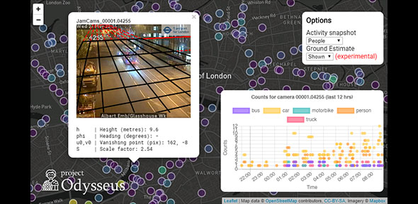
An example of the output from Project Odysseus' image processing algorithms. The map shows locations of JamCams (run by Transport for London) and the image shows a snapshot from one of the cameras. The plot (bottom right) shows the number of buses, cars, motorbikes, people and trucks detected by the image processing algorithms.
This article was first published by the Department of Engineering, University of Cambridge, and is republished here with permission.

