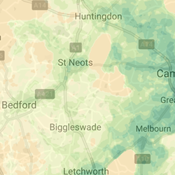
This project builds on a tool developed by two Cambridge PhD students that allows for the generation of high-resolution geographical data heat maps. These heat maps can help to solve optimisation problems relevant to citizens’ everyday lives. Specifically, we investigate how the interdependence between infrastructures and assets can be studied using transportation data.
Outcomes
We conclude that large-scale data repositories like Google Maps can be used within asset management solutions and criticality analysis. We are confident that we can solve a large number of problems related to criticality, transport and infrastructure, both for private companies and local or regional administrations. Our exploration of issues faced by the private and the public sectors in the UK showed that both companies and local governments have questions about transportation, criticality and infrastructure, and that they see our contribution as a useful addition to their existing applications.
Method
Prototyping
Case Study
Next Steps
This tool should be co-developed alongside potential end users to ensure that it is usable and useful for its intended audience.