Submitted by Angela Walters on Mon, 16/11/2020 - 14:38
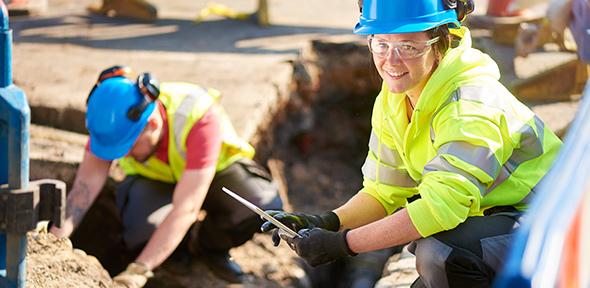
Every construction and infrastructure project must source information on buried utility assets (e.g. cables, pipes, sewers, ducts) when preparing ground investigation and excavation work in order to avoid costly damage to assets, and to safeguard personnel and the general public. Multiple organisations have to be contacted with data delivered in varied formats, scales, quality, and on different timelines. Current practice is inefficient and can result in increased project delays, cost overruns and disruption to traffic, local economies and safety risk.
The Geospatial Commission believes the current system is unlikely to reform itself without government intervention as there is no single actor who bears these wider societal costs.
The Geospatial Commission is working with 42 stakeholders to test the feasibility of creating a single, standardised data-sharing platform for the location and disposition of buried assets to enable safer and more efficient working. A prototype (static planning model) platform has been developed and used in field and office based trials and provided a significant test for the application of the Gemini Principles.
The potential benefit of intervention after adjusting for optimism bias is £245m per annum in real terms.
- A total of 42 asset owners participated including local authorities, utilities, infrastructure providers and transport agencies
- This static model of a system, takes inputs from the physical twin via corporate systems via periodic uploads and APIs
There are three sources of value:
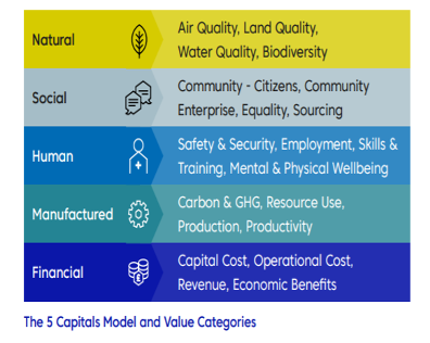
- utility strike avoidance, safe digging (social)
- project efficiency (financial)
- data exchange efficiency (manufactured)
Sharing often imperfect data with others, especially in a competitive environment requires trust to be developed in the sharing community and to see the bigger picture. As proven by many other digital transformation initiatives it is about people and processes not purely about technology.
Significant effort was made to liaise with stakeholders from central government and regulators, professional and academic organisations, the technology sector and of course asset owners and contractors themselves. The project built on strong local grassroots networks, established a diverse and competent advisory group, engaged with all parts of the United Kingdom and leading organisations overseas. The project team communicated and listened clearly and openly through workshops, seminars, webinars, direct conversations and professional and social media.
The aggregation of digital data, in particular of critical national infrastructure poses security risks. As buried assets are owned and operated by commercial organisations there are additional concerns about the disclosure of information.
Although only intended as a prototype, the platform adopted a security-minded approach to the disclosure of asset information. Advice was sought from the Centre for the Protection of National Infrastructure (CPNI), the National Cyber Security Centre (NCSC) to address national security and asset owners were consulted regarding their commercial and security concerns. As a result, the delivery team was able to deliver a working prototype that is secure by design.
Data sharing agreements were signed between all 42 public and private sector organisations participating in the pilot. This alignment of operational requirements and a risk-based legal approach has been a major milestone for the pilot project.
Asset owners continued to own, manage and take decisions on their own data. This principle is expected to continue through future phases of the programme.
Testing and development – taking an agile approach
Having clearly defined use cases helped to tell the story about the need for NUAR and reduced scope creep.
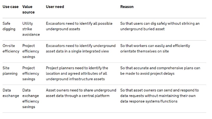
The benefits of shared digital asset data go well beyond the strike avoidance use case in particular in relation to street works management, infrastructure / broadband rollout, network management, local planning and housing delivery. Although we may be interested to pursue these in the future we are taking an incremental approach starting with the highest value use case. Any extension to the use cases needs to be done in cooperation with asset owners and will be subject to a further security review. The team uses agile development principles to deliver value for participants in short cycles, and maintaining close contact between platform developers and end users.
A simple, functional and well designed user interface is crucial to allow adequate user testing and feedback for any prototype.
Technology is a key enabler but was not the critical success factor in the pilots. The focus was firmly on the stakeholders and processes dealing with underground asset data. The NUAR prototype platform is not a live service; it is a first step towards building a national platform for the UK.
The data model was based upon an international standard (MUDDI) under development by the Open Geospatial Consortium (OGC) which informed our approach about bringing data together from disparate organisations and sectors into a common, harmonised structure. This harmonisation will be critical for long term success, and we will be refining the model to ensure it is extensible and allows data to be consistently used.
The current model and approach is unlikely to realise the full economic potential of a national register but the incremental approach is required to satisfy data sharing agreements.
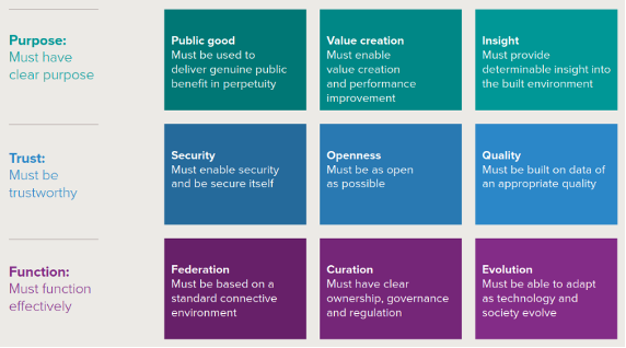
Public Good
NUAR’s objective is to help save lives and reduce the disruption caused when pipes and cables are struck by mistake. A perpetual and national system would benefit society as a whole.
Value Creation
The potential benefit of NUAR is £245m per annum with indirect costs (injuries, loss of service and traffic disruption) estimated at 1.2£billion every year.
Insight
The NUAR pilot platform provided a comprehensive, trusted, up-to-date and secure view of all buried infrastructure assets at a given location and a route to improving workforce safety.
A feedback mechanism is provided to test how to promote incremental improvement of data accuracy and completeness.
Security
CPNI, OS, asset owners and lawyers worked to ensure that there are effective access controls and that the platform is secure by design. The requirement is to share data without compromising critical national infrastructure or sensitive sites.
Openness
The level of access and openness has been set as a compromise between the need for security and access to deliver its purpose. NUAR is not an open platform but a shared platform accessible to underground asset owners, providing role-based access with protocols in place to ensure that the data is used for set purposes.
Strict data sharing agreements and access control stipulate access to all asset owners and their supply chains
Quality
NUAR partners have agreed to conform with a common and extensible data model which is fit for the purpose of strike avoidance when sharing data. The NUAR platform simply publishes data “as is” and provides a feedback loop facility to flag data quality issues to data owners.
The prototype system also included an observation feature so that field crews can record unidentified or wrongly located assets and feed information back to the asset owners. It is anticipated that collaborative sharing and developing of trust in the platform and its users will lead to incremental improvement of data
Federation
Ownership and control of data remains with asset owners but the pilot system has implemented a hybrid model with a pragmatic approach allowing some asset owners to upload to a central database.
Curation
Participation in the NUAR pilot phase was voluntary and asset owners continued to own, manage and take decisions on their own data, and any existing positions over liabilities remained the same.
Evaluation
The NUAR discovery and technical reports, system architecture and data model are documented and accessible. The federated approach and flexible architecture assures the system’s adaptability. Project Iceberg (an initiative between the Ordnance Survey and the British Geological Survey continues to evaluate and prioritise use cases beyond strike avoidance for future consideration.
Conclusions
The NUAR pilots were an ambitious undertaking in the number of asset owners who were required to collaborate to deliver a connected digital twin with a clear function of improving the safety of operations associated with underground assets. In delivering the pilot studies the GC tested many of the Gemini Principles, in particular relating to purpose and trust. As the output is a static model the principles of federation and curation were not explored. Security considerations and purpose defined data sharing agreements limit the model’s open-ness and value creation applications.
Contact: NUAR Team, Geospatial Commission