Submitted by Angela Walters on Mon, 22/03/2021 - 12:54
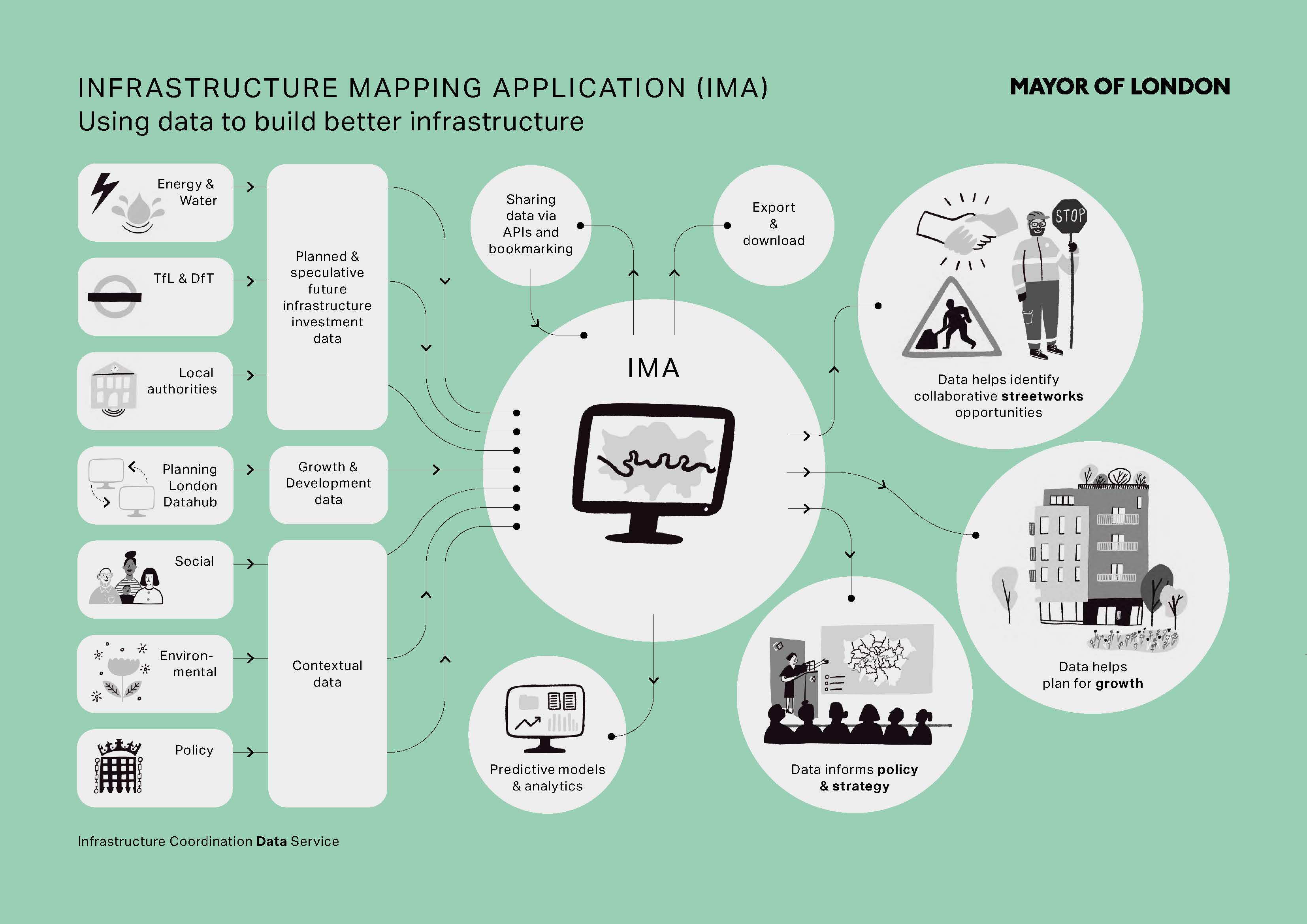
The Infrastructure Mapping Application for London (IMA) seeks to address London’s need for improved coordination around infrastructure delivery to minimise disruption. The Greater London Authority (GLA) created the tool in 2015 to provide insight into London’s future growth, development, and infrastructure investment trajectory, as well as support opportunities for infrastructure providers to deliver infrastructure services in a 'joined up,' and less disruptive way.
The tool supports boroughs, utilities, contractors, TfL, National Grid and the Environment Agency in planning, infrastructure policy, coordinated streetworks planning and delivery and strategic work with regulators. The map is both a shared digital workspace and a database which supports decision-making.
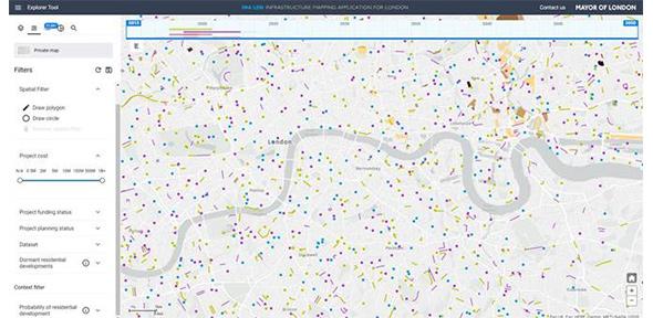
From a prototype in 2015, the tool has become a central decision-making tool for the GLA’s Infrastructure Coordination Service (ICS). The IMA is a browser-based GIS tool storing and displaying future investment and growth data pertaining to infrastructure and the built environment in London.
Funding and use case
Utility providers appreciated the need for improved data sharing to avoid repetitive road resurfacing, so funded the tool’s development through TfL’s Lane Rental Surplus Fund. The project is overseen by the Mayor's London Infrastructure Group and managed by the GLA Infrastructure Coordination Service (ICS).
The IMA is a composite database, bringing together data feeds from across London e.g. Thames Water’s Thames Connect, Environment Agency’s TEAM2100 programme, Planning London DataHub (previously LDD), and GLA social and demographic layers. The IMA team does not own or create the data, but processes data from other teams and organisations, manages the tool, and advances the future data sharing agenda in the sector. Unlike other tools, the IMA shows plans from 6 months to 30 years into the future, with the understanding that some of the future data is speculative.
A public version of the IMA is used by academics, developers, architects and public policy professionals. There has been an average of 15,500 annual page views since 2018. The restricted site, accessible to 21 NDA signatories, is used for streetworks coordination and planning infrastructure in line with growth.
The key drivers for the project are;
-
Planning for growth: increasing the efficiency of infrastructure delivery across infrastructure sectors (gas, water, electricity etc.) and between governance organisations facilitating coordination of major disruptive works.
-
Infrastructure coordination: data on speculative and planned infrastructure works in the same location and timeframe allows users to find opportunities for collaboration in delivery e.g. sharing a trench.
-
Data sharing across the sector: Fragmentation of ownership within London’s infrastructure sector makes data sharing challenging, with many different private and public stakeholders with varied (and siloed) data taxonomies and formats. The IMA is the only central register of infrastructure investment data.
Engagement
The IMA's annual page views grow year on year and have exceeded targets.
- March 2019 - March 2020: 17,383
- August 2019 - August 2020: 18,422
- October 2019 - October 2020: 19,621
Usage to inform plans and activities.
Use of the IMA to identify prospective joint streetworks opportunities is now becoming common practice, and the team sift new data quarterly. The IMA identified 78 potential opportunities in the Spring 2020 shortlisting exercise, of which 18 (23%) made it to the shortlist. When the shortlisting exercise was completed in Autumn 2020 the IMA identified 99 potential opportunities, of which 78 (79%) made it to the shortlist. The quality of opportunities identified has increased substantially as a result of new data received.
Accessibility and Improving the quality, quantity, reliability and usability of data
In 2019 the IMA team processed 27 future investment datasets which had increased to 74 in 2020. There has also been an increase in available contextual data and the volume of data has grown so substantially that enhancements to the IMA’s architecture have been required as well as new APIs which now support analysis of operations and strategic decision-making.
Outcomes
Streamlining of streetworks, e.g. sharing a trench, results in reduced costs for providers and a significant reduction in streetworks days, meaning less road network disruption, noise and access issues for all road users, including pedestrians.
A recent new development is the integration of a Minimum Viable Product (MVP) Benefits Calculator in Hackney to approximate and prioritise the benefits of streetworks collaboration. It estimates the impact of the collaboration on road user time savings from a simple road network model with changing traffic speeds, use of alternative road sections and estimated days of disruption saved.
New analytical developments using contextual data include the ‘Probability of Development’ feature which predicts the likelihood of developments being completed by a given date (currently at 80% accuracy when tested on historic data). This functionality is used by investment and network planners at various utilities to better understand the projected growth in their catchment areas to assess their priorities for the upcoming regulatory period.
Barriers for achieving these KPIs and how were these barriers overcome
Data provision is dependent on partner capacity and engagement
The GLA has no regulatory powers to improve data quality or data sharing, but through collaboration, trust has been built with the partners leading to real improvements in data sharing across the infrastructure sector. Nevertheless, progress is contingent upon partners investing in data creation, maintenance, sharing and engagement. The positive impact of trailblazing partners on others involved in the project has been significant. For example, sharing data on assets with a higher risk rating for replacement.
Improving data quality is a process which requires continual support and engagement:
The IMA works with a diverse range of stakeholders, all of whom are at differing stages of technological maturity and with differing capabilities to support data sharing. There are immediate improvements required – for example to standardize data refreshes and improve data flow – even as data requirements are anticipated to change.
The importance of articulating the benefits of infrastructure data sharing:
Attributing the improved outcomes that the tool enables, including reduced days of disruption, healthier streets and more useful data for the providers, continues to be challenging. Articulating these benefits will be critical to catalyse data providers to invest adequately in data provision and quality to address the points above .

What is the fit with the Gemini Principles?
|
Purpose |
Public Good |
Value Creation |
Insight |
|
Yes |
Yes |
Yes |
|
|
Trust |
Security |
Openness |
Quality |
|
Yes |
Yes |
Yes |
|
|
Function |
Federation |
Curation |
Evolution |
|
Partial |
Yes |
Yes |
Public Good
Facilitating data exchange across the infrastructure sector benefits both infrastructure providers and the public.
The IMA benefits utilities, transport providers, Londoners and the public through:
- cost savings through the avoidance of repetitive road resurfacing
- collaborative streetworks result in less road network disruption, noise and access issues.
- sustainable growth
- improved resilience of infrastructure networks by understanding interdependencies.
Value Creation
Value is created for the GLA and may also be captured by utilities through the better use of improved data.
1. Insight
IMA analysis are included in infrastructure providers’ business cases to regulators and investment planning analysis. In addition, the GLA has gathered learning from the creation of the IMA. This includes how to tackle the common barriers to data sharing, such as legal agreements and culture change. All of this has potential for replication in other cities.
2. Security
The IMA public site is available to all, but the private IMA site is only available to parties who have signed an NDA. The GLA only asks for specific data, to meet specific use cases, to be shared with specific groups. Use of the London Datastore ensures that data is shared securely and with an audit trail.
3. Openness
A private site is necessary to enable sharing of more sensitive data, but all contextual data and planning data from Planning London DataHub is freely available on the public site. There have been almost 20,000 views in the past year.
4. Quality
The GLA has convened data providers and encouraged them to share best practice with each other, which has led to an increase in quality and quantity of data provision.
5. Federation
The data sits in a single repository which the GLA manages. The GLA maintains a flexible IMA schema and, when necessary, can support data providers in mapping their data to it. The data is verified in partnership with data providers, but data owners maintain ownership of their data.”
6. Curation
GLA maintains the IMA, as well as providing full time support to manage the data and its stakeholders to ensure continued success. The GLA verifies data in partnership with data providers to map it to the IMA schema, but data owners maintain ownership of their data.
7. Evolution
The IMA has met its viable product definition and more; it has grown in scope from being a digital prototype, to a digital service which has generated significant improvements to data-related processes in the sector.
As a digital service the IMA is now an essential component of the Infrastructure Coordination Service (ICS), providing valuable data for the ICS and wider users. Thanks to the widening range of data displayed in the IMA from our growing stakeholder network, the ICS is now able to consider more complex collaborations with greater potential to reinstate London’s streets better than we find them.
Conclusions
The GLA intends to continue developing and evolving the IMA to meet demand, so it can support the coordination of delivery and reduction of road network disruption across London for years to come.