")
Submitted by Anonymous on Wed, 05/10/2022 - 10:14
Satellite Interferometric Synthetic Aperture Radar (InSAR) monitoring to investigate large earth movements and monitor city-scale deformation is well established. The use of InSAR to monitor single infrastructure assets has been less well understood. Yet improvements in the achievable resolution mean the range of possible applications is increasing rapidly. What can we meaningfully measure with satellites, how can we improve and interpret measurements effectively, and what kind of useful information can we provide for asset owners?
Previous research highlighted the potential for satellite technology techniques to pick up precursors to failure, as well as understand the accuracy and uncertainty of measurements with respect to more widely used sensors, surveying and other methods traditionally employed to study structural behaviour (AMSIT, 2017). CDBB researchers set out to develop methods to incorporate insights from satellite monitoring into digital information models used by built environment asset owners, as well as explore the possibilities of using data science to extract key insights from these large and ever-growing datasets. The goal is to improve whole life performance and quality of assets through more effective monitoring and operational maintenance, based on satellite data.
Big Picture
Deterioration and failure of critical infrastructure, such as bridges, dams and tunnels, can lead to costly repairs, disruption to transport networks and, at worst, loss of life. The catastrophic failure of the Polcevera Viaduct in Genoa (the Morandi Bridge) in 2018 resulted in 43 deaths and left 600 people homeless. Closer to home, early reports of the closure of Hammersmith Bridge in West London stated it may remain closed for six-and-a-half years; the extremity of disruption was sufficient to identify a quicker response (involving a temporary structure and offsite repairs) but costs to stabilise and strengthen the structure are set to surpass £100 million, with the bridge closed to motorised vehicles for more than three years. Only by better understanding the condition and structural health of our assets and the effects of the environment around them can we schedule effective maintenance and make informed operational decisions. Robust and reliable data can leverage whole life value of an asset or portfolio of assets by informing more efficient asset management.
The case for change
Infrastructure and built assets in remote and hard to access locations make monitoring challenging, high risk and costly. Satellite monitoring can provide regular data to help build a fuller picture of the structural health and behaviour of an asset. Satellite monitoring does not require a power source, covers the entire earth and—with radar—can image continuously through clouds, day and night.
The project
Interferometric Synthetic Aperture Radar (InSAR) imagery maps ground deformation using radar images of the Earth’s surface collected from orbiting satellites. It can be used to monitor millimetre-scale movements of built environment assets over time. This technique can capture measurements on a regular basis to provide continuous monitoring. It also provides the opportunity to look back through historic archives, and get measurements over sites where no other information was collected. Radar images and measurements taken of the same area or asset collected at different times can be compared to look for changes in movement.
Researchers investigated the capabilities of satellite monitoring to evaluate and demonstrate the potential use and value of this technique for construction and infrastructure owners and operators. The team set out to establish the surveillance requirements of different assets (based on geography and material), in order to develop methodologies for a range of asset types and geographic locations. These ranged from bridges and tunnels in central London to road/rail embankments in the Midlands. The research should support deployment of such technologies in future schemes such as the new high speed railway line (HS2).
Employing data at different spatial and temporal resolutions, this project studied the quality of InSAR measurement data to better understand its suitability for use in structural monitoring. Combining structural modelling and understanding with InSAR, the team considered effects such as thermal expansion, worked to identify unusual or anomalous behaviour in structures, and explored how changes over time might represent a precursor to problems. In addition, the researchers investigated how new metal reflector designs (creating satellite monitoring points) might augment structures to amplify responses, enabling use of free medium-resolution data from European Space Agency satellites. The applications of big data analysis, including machine and deep learning, to automatically extract specific insights from satellite monitoring were also explored.
Findings have been summarised for industry audiences, with more detailed accounts of the research published in peer-reviewed journals.

Corner reflectors on the field near Tadcaster
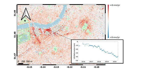
Map of estimated average velocity from 6 March 2015 to 6 Sep 2020 using InSAR technique with Sentinel-1 images (SatSense), showing signal of deformation for northern line extension from Kennington to Battersea station and for dewatering works associated with Thames Tideway.
Meet the research team
Lead: Professor Tim Wright, Professor of Satellite Geodesy, University of Leeds; Dr Sakthy Selvakumaran, University of Cambridge
Team: Dr Gabriel Martin Hernandez, Senior Research Associate, Laing O’Rourke Centre for Construction Engineering and Technology, University of Cambridge; Dr Zahra Sadeghi and Dr Krisztina Kelevitz, Research Associates, University of Leeds; Professor Andy Hooper, Professor of Geodesy and Geophysics, University of Leeds
“This research in academia has immediate applicability to society by expanding InSAR remote sensing applications into infrastructure monitoring.”
“Many bridges are only inspected visually every few years. We are excited by this technology as it can potentially provide real monitoring data for all bridges and can possibly provide an early warning of any structural issues.”

“The use of machine learning technologies on the evaluation of the data obtained from assets will allow us to monitor and assess these structures at large scale in an automatic fashion. As satellite images collect data from large areas continuously, it would not be cost effective for experts to evaluate this data manually and at scale.”

Find out more
Learn more about this research and its outcomes on the project page here.