Submitted by Angela Walters on Wed, 27/01/2021 - 16:13
Dr Sakthy Selvakumaran, Department of Engineering at the University of Cambridge, and Dr Cristian Rossi, Satellite Applications Catapult, call for infrastructure owners to work with the research teams leading cutting-edge work exploring the capabilities of satellite tools to better monitor assets. This research builds on a CDBB and Catapult Knowledge Exchange event held in November 2020 which brought together a number of leading experts in satellite monitoring of infrastructure – including the University of Cambridge, University of Leeds and the Satellite Applications Catapult.
Dealing with the COVID-19 pandemic has been a huge test for many and highlighted the importance of the resilience of infrastructure and its associated services to keep the country, its cities and communities functioning and flourishing. Our infrastructure is a complex and interconnected system that plays a vital role in people and society’s wellbeing as well as to our economy. Monitoring the individual assets that combine to create our infrastructure ecosystem is essential to ensure they are fit for purpose throughout their whole performance life – from construction to operation, maintenance and upgrade.
The systems nature of infrastructure means the effects of one failure can be felt far beyond the asset itself; an underground pipe bursting may require road closure which, in turn, disrupts traffic, can cause congestion and increase localised air pollution while leaving a number of households and businesses without water. Some failures cause serious damage and even loss of life – when the Morandi Bridge in Italy collapsed in August 2018 the tragedy killed 43 people and left around 600 homeless.
Much of UK infrastructure is ageing and performing beyond its design life and intended capacity. In order to get more out of our existing assets with minimum use of limited resource we need to better understand how they are performing. Climate crisis and extreme weather events bring additional strain to the condition and structural health of assets making assessing their condition increasingly important. There are logistical challenges too – visually inspecting remote and hard to access assets can be expensive and hazardous.
Coming together for the Knowledge Exchange event was an opportunity to hear updates from all the teams working in this area and to explore future opportunities to collaborate. As part of the Cambridge and Catapult teams, we worked together in 2017 as part of the ‘Asset monitoring using satellite and Internet of things technology’ (AMSIT) project that lay the ground for Catapult’s Brigital project that is developing an early warning tool comparing automatically predicted movements against satellite measurements. This indicates potential problems to asset managers and allows for early intervention. AMSIT was also the precursor to a current project at Cambridge further exploring the potential of satellite monitoring for infrastructure.
Advances in sensor systems, digital tools and technologies and data analysis brings the possibility of smart infrastructure solutions to expand our monitoring tool kit. CDBB is supporting collaborative research between experts at the University of Cambridge and Leeds University who are leading the field in exploring the capabilities of satellite monitoring for infrastructure. InSAR (Interferometric Synthetic Aperture Radar) imagery taken by satellites can be used to monitor millimetre-scale movements of built environment assets over time and can deliver up to 25cm resolution data. Satellite monitoring can provide regular data to help to build a fuller picture of the structural health and behaviour of an asset – it does not require a power source, covers the entire earth and radar can image continuously through clouds day and night.
Significantly, satellites allow large-scale nationwide monitoring of the structural health of bridges, rail networks and other infrastructure, and could be important in forecasting potential failures or collapses. Developing automatic mechanisms of evaluation will be key to assessing large areas at scale. Machine learning and deep learning technologies provide a solution for automating these tasks; they are able to learn complex features and model non-linear behaviours such as those seen in complex structures. Once trained, they provide a powerful automated tool to support structural health monitoring and assessment. As one of the Construction Innovation Hub’s digital twin demonstrators, we have learnt how we can incorporate earth observation technology into the technology specification of a digital twin platform. InSAR technology will play an important role in passively capturing the characteristics of assets that are observable from space. Their nonintrusive and temporal nature allows a new resolution of data acquisition to be fed into the decision-making for operational assets.

A traditional corner reflector, size of 1m. Credit Krisztina Kelevitz
The research teams are combining expertise to test and assess InSAR, compare results with more traditional monitoring and embed new practice into current methods. We are currently developing methods to incorporate insights from satellite monitoring into digital information models used by built environment asset owners to improve the whole life performance and quality of assets through more effective monitoring and operational maintenance based on the data provided.
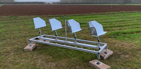
It is a potentially exciting development, we have been working on designing and testing a new array of corner reflectors suitable for infrastructure monitoring. Corner reflectors are angular structures (see pictures) that reflect radar signal when directed towards InSAR satellites. In rural areas well reflecting point-targets are sparse or non-existent, so installing corner reflectors can give great certainty in ground movement in these areas. In urban areas many angular structures exist, but there is an advantage of installing corner reflectors at known locations throughout the area of interest that can be used to validate InSAR measurements with other ground-based deformation monitoring measurements.
The reflectors designed for this project aim to enhance existing and freely available Sentinel-1 InSAR measurements. They are smaller than traditional reflectors and we will test whether several small reflectors can be used rather than the larger metre-scale corner reflectors which are traditionally used for ground motion measurement but not suited for deployment on structures such as bridges. The design, manufacturing, and deployment of these reflectors have been completed and researchers are currently collecting InSAR and Global Navigation Satellite System (GNSS) data in order to test how well they work.

Newly designed reflector array, 4 corner reflectors of 33cm size. Credit Krisztina Kelevitz
We want our research to make a real difference to infrastructure asset owners. Our work builds on established relationships with a number of asset owners and we are collaborating to capture user requirements and obtaining feedback on designs and implementations. This approach steers outcomes of the research project towards deliverables that can be used in practice by asset owners. We would also welcome additional infrastructure asset owners to work with us; sharing monitoring data would enable us to create more case studies that demonstrate the best use for and describe the benefits, opportunities and limitations of satellite monitoring for infrastructure.
Case studies from this project will support industry to better understand satellite monitoring technology in the context of infrastructure and construction. Bespoke trials are costly exercises for suppliers who are often small SMEs with limited financial means and this project will provide assessment of the technology. If you would like to be part of these exciting developments, please do get in touch.
Contact: Dr Sakthy Selvakumaran,
Project page: Application of satellite technology in infrastructure monitoring